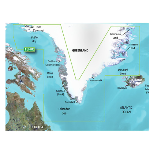
Garmin - BlueChart g3 Vision HD Electronic Chart - VEU064R, Greenland, microSD/SD
-
Perfet Fit, Guaranteed
Get the right part every time
-
Expert Support
Our in-house specialists know our products inside and out
-
Enhanced Value & Service
We go beyond the sale with professional and balanced services
-
Wordwide Delivery
Enjoy hassle-free worldwide delivery
Embark on an Adventure: Greenland's Marine Topography Revealed!
With the BlueChart® g3 Vision® HD - VEU064R, take a deep dive into the intricate details of Greenland's western coastline, stretching from the charismatic Thule (Qaanaaq) all the way to the serene Lindenow Fjord (Kangerlussuatsiaq) located on the SE coast. Dive into an exploration journey like no other, encapsulating the enchantment of Ikerasak, Holsteinsborg (Sisimiut), Godhavn (Qeqertarsuaq), Godthab (Nuuk), Julianehab (Qaqortoq), and the breathtaking Nanortalik.
Charting Perfection: The Tech Beneath!
With the integration of elite Garmin and Navionics® content, expect nothing short of industry-leading coverage coupled with pristine clarity and detail. With the innovative Auto Guidance feature, pave your way through the waters, keeping safety paramount. And what’s marine exploration without a little adventure? Dive into the Depth Range Shading, delineating up to 10 depth ranges, offering a riveting portrayal of the marine terrain.
Dimensional Elegance: What’s Underneath?
Witness the magic of marine dimensions with the breathtaking FishEye View, a mesmerizing 3-D representation of the ocean floor and its contours. Couple this with the MarinerEye View, providing an unparalleled 3-D portrayal of both, above and beneath the waterline. Elevate this experience with High-resolution Satellite Imagery, overlaying navigational charts, making it the ideal guide for entering uncharted territories. Complimenting this is the crystal-clear aerial imagery, spotlighting many ports, harbors, and marinas.
Art of Craftsmanship: Finishes and Textures
What stands out in the BlueChart® g3 Vision® HD - VEU064R is its intricate detailing. From the precise 1’ contours illustrating the ocean's bottom structure to the invaluable Shallow Water Shading, ensuring you remain aware of potentially treacherous areas - every feature has been crafted with precision and expertise.
Captivating Highlights
- Integration of pioneering Garmin and Navionics® content
- Innovative Auto Guidance for a secure marine journey
- Detailed Depth Range Shading for target depth visualization
- Enhanced detail in swamps, canals, and port plans
- Remarkable satellite imagery paired with navigational charts
We ship all in-store (FL) stock orders the same day if placed before 3 PM EST, Monday through Friday. Orders placed after this time will ship the next business day. Orders fulfilled from other warehouses or manufacturers may not ship the same day. If an item is out of stock, we will notify you promptly.


